




Where is Patagonia? At the southern end of South America, shared by Argentina and Chile, in a strip of land about 1,800 km long that runs from the Colorado River down to Cape Horn. It is a region, not a country, and no single border line closes it on the north. What that means at the border is in our guide on whether Patagonia is a country.
That answer fits in a sentence, but it does not help you pick an airport. The questions that matter when you plan are different: how far apart are the places you have heard of, which side of the Andes are they on, and which city do you fly into first. This guide answers those with a map in numbers, built from coordinates, not from brochures.
Where is Patagonia in South America?
Patagonia is the southern tail of the continent. The Andes run down its western side like a spine, with Chile on the Pacific slope and Argentina on the long, dry plateau that slopes east to the Atlantic. At the bottom, the Strait of Magellan separates the mainland from Tierra del Fuego, and Cape Horn marks the last piece of land before Antarctica.
Three facts explain most of what you will see on a map:
- The border follows the mountains. Argentina holds the larger eastern side, with steppe, coast and the big lakes. Chile holds the western edge, with fjords, forests and the Pacific side of the ice fields.
- The two countries share the same landscapes. Glaciers, lakes and peaks do not stop at the line, which is why a single trip can cross it several times.
- Distances are long and the population is thin. One southern Chilean region, Aysén, has 100,745 people in 108,494 km², according to Chile’s national library and the 2024 census of the national statistics institute. That is fewer than one person per square kilometre.
If you are already comparing routes, our Patagonia tours show how these places connect in a real itinerary, with the border crossings handled for you.
Where is Patagonia located on a map?
Most maps show place names but not the numbers that decide a trip. So we calculated them.
That matters because Patagonia is long and thin. Two famous bases can sit 120 km apart or more than 1,500 km apart, and a flat map hides the difference. A country name or a town name does not tell you which of those two cases you are looking at, but a number does.
Read the latitude column first. It tells you how far south you are, which says more about the cold and the length of the day than the name of the country does. Then compare the two right hand columns to see which capital is the closer door to each base.
The Patagonia First-Timer's Guide
Download the practical side of Patagonia in one guide: real driving times between bases, how park tickets and discounts work, what you can't take across into Chile, and a worksheet to get a sharper quote.
The map below marks nine bases, and the table after it gives the latitude of each one and the straight line distance from Buenos Aires and from Santiago, using the coordinates of each town centre and rounding to the nearest 10 km.
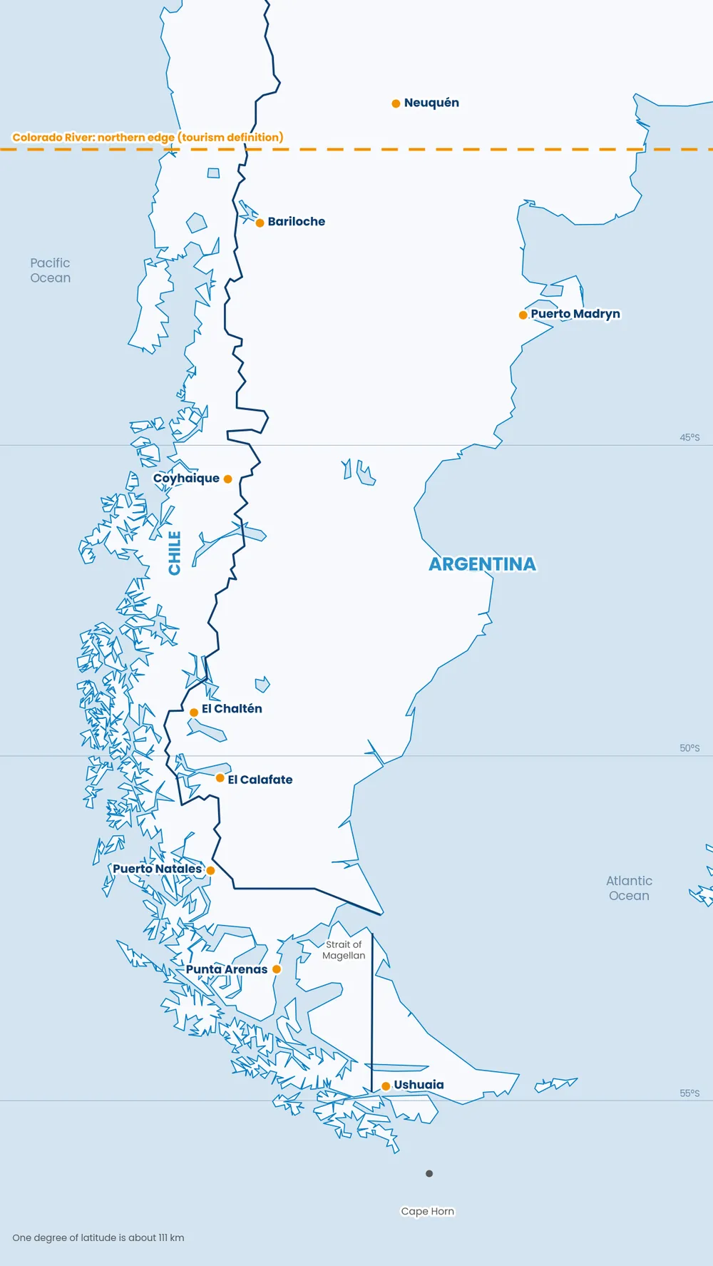
Map by Argentina Pura. Orange dots mark the nine bases in the table. The dashed line is the Colorado River latitude.
| Base | Country | Latitude south | From Buenos Aires | From Santiago |
|---|---|---|---|---|
| Neuquén | Argentina | 39.0 | 990 km | 660 km |
| Bariloche | Argentina | 41.1 | 1,350 km | 860 km |
| Puerto Madryn | Argentina | 42.8 | 1,080 km | 1,150 km |
| Coyhaique | Chile | 45.6 | 1,680 km | 1,350 km |
| El Chaltén | Argentina | 49.3 | 2,020 km | 1,780 km |
| El Calafate | Argentina | 50.3 | 2,080 km | 1,880 km |
| Puerto Natales | Chile | 51.7 | 2,210 km | 2,040 km |
| Punta Arenas | Chile | 53.2 | 2,290 km | 2,190 km |
| Ushuaia | Argentina | 54.8 | 2,370 km | 2,380 km |
Straight lines are shorter than any flight path or road, so read them as a measure of scale, not of travel time. Our Patagonia itinerary guide turns the same places into days.
Three things stand out once the numbers are side by side.
- Santiago is closer to most of Patagonia. Bariloche is 860 km from Santiago and 1,350 km from Buenos Aires, and the same holds for every base in the table except Puerto Madryn, which is closer to Buenos Aires, and Ushuaia, where the two are tied. Closer on the map does not always mean easier to fly, so check the connections before you choose.
- Ushuaia is the tie. It sits 2,370 km from Buenos Aires and 2,380 km from Santiago, so the gateway you pick there is a matter of connections, not distance.
- The famous places are close to each other, and far from everything else. El Calafate and El Chaltén are 120 km apart in a straight line, and El Calafate and Puerto Natales, the gateway to Torres del Paine, are 155 km apart. From El Calafate to Ushuaia is 560 km, and from Bariloche to Ushuaia it is 1,540 km.
For scale, the distance from the mouth of the Colorado River to Cape Horn is about 1,840 km in a straight line. That is longer than New York to Miami, which is about 1,760 km.
Where does Patagonia start and end?
Nobody agrees on the northern edge, and that is why search results disagree too. Three definitions are in common use.
- The tourism definition. Argentina’s national tourism board describes the region as beginning south of the Colorado River. This is the one we use for the table above.
- The legal definition. For national legal purposes, Argentine Law 25,955, published in the official gazette in November 2004, groups La Pampa, Río Negro, Neuquén, Chubut, Santa Cruz, Tierra del Fuego and the Patagones district of Buenos Aires Province under one heading. That is a legal convention, and it includes places no traveller visits for the landscape.
- The Chilean side. The southern regions of Aysén and Magallanes belong to almost every definition. Whether the lake district around Puerto Varas counts is a matter of taste, and we treat it as the doorway rather than the heart of the region.
If a source quotes a different size or a different list of provinces, check which of these it is using before you compare numbers.
Where is Patagonia in Argentina?
Argentine Patagonia covers the provinces of Neuquén, Río Negro, Chubut, Santa Cruz and Tierra del Fuego, which is the eastern and larger share of the region. It gives you three different trips depending on latitude:
- The northern lakes. Bariloche sits in the lake district at 41 degrees south, with forest, mountains and a network of lake circuits.
- The Atlantic coast. Puerto Madryn faces the sea at 43 degrees south, closer to Buenos Aires than to any glacier.
- The south. El Calafate, El Chaltén and Ushuaia sit between 50 and 55 degrees south, where the ice fields, the granite towers and the end of the continent are.
We cover these bases in El Calafate tours, Ushuaia tours and Bariloche tours.
Where is Patagonia in Chile?
Chilean Patagonia is the narrow western strip. Aysén holds the Carretera Austral, the long road through forest and fjord that links small towns such as Coyhaique. Magallanes holds Punta Arenas, Puerto Natales and, nearby, Torres del Paine National Park, which is why Puerto Natales and El Calafate work so well as a pair even though they are in different countries. Our Torres del Paine visitor guide gives the distance from Puerto Natales to each park entrance.
How do you get to Patagonia?
Almost every international trip arrives in Buenos Aires or Santiago, then continues on a domestic flight to a Patagonian gateway. The common gateways are:
- El Calafate for the glaciers and El Chaltén.
- Ushuaia for Tierra del Fuego and the end of the continent.
- Bariloche for the northern lakes.
- Puerto Madryn for the Atlantic coast.
- Punta Arenas and Puerto Natales for Chilean Patagonia and Torres del Paine.
Choosing the first gateway is easier once you know which bases you want. If your list is El Calafate, El Chaltén and Torres del Paine, the distances above show that you can do all three in one arc without doubling back. If it includes Ushuaia, plan the Strait of Magellan and the long jump south as a separate leg.
Two figures from our own itineraries show why straight lines understate the trip. El Calafate and Puerto Natales are 155 km apart on the map, but the road is about 270 km and takes roughly 5.5 to 6 hours with the border crossing. The flight from El Calafate to Ushuaia takes about 1 hour 15 minutes. Schedules change by season and by airline, so we do not print them here. Our team confirms the current options for your dates, and our itinerary guides for five days and ten days show how the legs fit together.
What the map means for your trip
Patagonia is not one destination. It is a chain of bases spread over more than 1,800 km, and the useful question is which two or three you want to link. With that in mind, pick the length of the trip first and the gateway second. Ten days is usually enough to cover one region well, and a trip that tries to cross the whole map spends most of its time moving.
When you are ready to turn the map into a plan, talk to us about Patagonia tours. We run trips across Argentina, Chile, Brazil and Peru, with real people on call from the first message.

Due to my professional background, I have extensive skills in the identification and characterization of target audiences, which allows me to understand the needs, preferences and specific behaviors of each segment, in order to design effective strategies that contribute to the success of the organization’s communication goals.
I work in the creation of digital content and the design of narratives for companies in the travel and tourism sector, contributing significantly to the promotion of destinations, services and exclusive experiences, generating a positive impact on brand perception.
Throughout my career, I have acquired solid experience in project planning and management, and I am passionate about research and data analysis, especially oriented to the development of user-centric products.
My experience encompasses the development and implementation of sustainable practices in processes, for building solutions that generate positive impact both socially and environmentally.
Always committed to designing effective solutions, I am dedicated to address challenges and contribute to the growth and development of teams and organizations with a holistic and sustainable approach.

0 Comment